
Cyfrowa edycja mapy Gaula/Raczyńskiego (1:125 000, 1807-1812), Tomasz Panecki, Instytut Historii im. Tadeusza Manteuffla PAN jest dostępne na licencji:
Creative Commons Attribution-NoDerivatives 4.0 International![]()
![]()
![]() (treść)
(treść)
Cyfrowa edycja mapy Gaula/Raczyńskiego (1:125 000, 1807-1812), Tomasz Panecki, Instytut Historii im. Tadeusza Manteuffla PAN jest dostępne na licencji:
Creative Commons Attribution 4.0 International![]()
![]() (dane)
(dane)
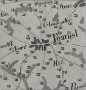
„Mappa topograficzna woyskowa i statystyczna części Wielkopolski, która dziś Departament Poznański składa wydana przez Edwarda Raczyńskiego Posła Poznańskiego i jego kosztem nowo układana w roku 1807–1812” w skrócie nazywana jest mapą Gaula/Raczyńskiego od nazwiska kartografa (Ernest Gaul) i fundatora (Edward Raczyński). Jest to dość typowa mapa topograficzna z przełomu XVIII i XIX w. opracowana w formie barwnego rękopisu prawdopodobnie w skali 1:125 000, ale nigdy nie ukończona. Do dziś pozostały jedynie dwa komplety czarno-białych fotokopii (w Archiwum Państwowym w Poznaniu i w Bibliotece Raczyńskich w Poznaniu), a oryginał zaginął podczas II wojny światowej. Mapa doczekała się cyfrowej edycji ze względu na jej znaczenie dla badań nad dawną Wielkopolską oraz z uwagi na fakt, że stanowi ciekawy materiał dający pełny katalog problemów edytorskich źródeł kartograficznych tego typu1.
Dzieło było prywatną inicjatywą Edwarda Raczyńskiego (1786-1845): szczegółowym obrazem i – jak sugeruje tytuł – mapą topograficzną, wojskową i statystyczną. Pracami topograficzno-kartograficznymi kierował, podpisany na mapie, Ernest Gaul (ur. 1775 r.): wielkopolski mierniczy, geodeta i kartograf. Był on dobrze przygotowany do tej pracy, chociaż – jak wykazała analiza mapy – nie uniknął pewnych błędów. Mapa Gaula/Raczyńskiego była w dużej mierze oparta na mapie Dawida Gilly’ego (1:150 000, 1802-1803), ale wprowadzano do niej pewne poprawki będące ewidentnie wynikiem pomiarów terenowych, jak np. znacznie bardziej szczegółowy obraz rzeźby terenu, dróg czy kształtu miejscowości. Mapa pozostała nieukończona i niewydana, ale jak na owe czasy była dość dokładna i szczegółowa.
Cyfrowa edycja, której szczegółowa dokumentacja znajduje się w monografii2, składa się z kilku powiązanych ze sobą komponentów:
- Skany arkuszy mapy. Jednym z celów prac edycyjnych było przywrócenie im najbardziej prawdopodobnego, oryginalnego wyglądu, więc elementem edycji są także arkusze kolorowe ze zrekonstruowaną na podstawie analizy innych, podobnych map kolorystyką. Ta część prac edycyjnych została przygotowana w ramach projektu przy współpracy z firmą ArtiFacts.
- Arkusze połączone w całość i skalibrowane: wpasowane we współczesny układ współrzędnych, co umożliwia wirtualne nałożenie mapy dawnej na współczesną. Mapa została skalibrowana z zastosowaniem transformacji Helmerta, która nie zniekształca obrazu zachowując źródłowe proporcję linii i kątów wpasowując go we współczesny układ współrzędnych z pewnym błędem. Błąd ten, jak na mapę z tego okresu, nie był duży i wahał się w zależności od arkusza od 229 do 502 metrów.
- Baza danych przestrzennych najważniejszych elementów treści mapy, takich jak miejscowości, obiekty przemysłowe, drogi i pokrycie terenu. Ogółem zindeksowanych zostało 1598 miejscowości, 1908 budynków i konstrukcji (np. wiatraków, młynów, leśniczówek), 468 obiektów przemysłowych (np. folwarków i cegielni) oraz 23 nazwy obiektów fizjograficznych. W bazie danych znalazły się także drogi główne oraz wybrane elementy powierzchniowe, takie jak: hydrografia, zalesienie i bagna. Dane te można pobrać w formie danych GIS.
- Aplikacja WebGIS, która umożliwia przeglądanie skalibrowanej mapy i danych kartograficznych w formie zwizualizowanej bazy danych przestrzennych, a także wykonywanie prostych analiz.
- Dane dostępne są również w formie usług danych przestrzennych zgodnych z Open Geospatial Consortium.
- Tradycyjna edycja drukowana w postaci pliku *.pdf. Osiem arkuszy mapy w wersji kolorowej zostało połączonych i wkomponowanych w jeden duży arkusz. Opracowany został także selektywny indeks toponimów.
- Edycja jest bezpośrednim efektem projektu „Cyfrowe edycje map dawnych: perspektywy i ograniczenia na przykładzie “Mapy topograficznej, wojskowej i statystycznej Wielkopolski” (1807-1812)” finansowanego przez Narodowe Centrum Nauki (nr 2015/17/N/HS3/01267). Jego celem było jednoczesne spojrzenie na edytorstwo źródeł kartograficznych z perspektywy kartografii i historii: spojrzenie mające uwzględniać zarówno kartograficzne metody badań wykorzystujące metody komputerowe i Systemy Informacji Geograficznej (GIS) oraz edytorstwo źródeł historycznych z jego zasadami dotyczącymi do archetypu, filiacji, drzewa genealogicznego i metod ustalenia tekstu.[↩]
- T. Panecki, Długie życie dawnych map. Opracowanie cyfrowej edycji mapy Gaula/Raczyńskiego (1:125 000, 1807-1812), Warszawa 2021.[↩]