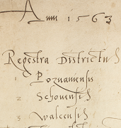
This edition consists of tax registers from the voivodeship of Poznań from the 2nd part of the 16th century presented in form of a map, spreadsheets and manuscript scans. It was prepared as part of works on the volume of the “Historical Atlas of Poland. Detailed maps of Poland in the 16th century” devoted to Greater Poland. So at the same time it is a preparatory stage of the publication, as well as its expansion. However, unlike the “Atlas” itself, this is not a secondary source, but a compilation of historical primary sources provided with critical apparatus: individual entries are assigned to relevant columns of the table and to points in space. This brings order to the content and introduces some elements of interpretation, thus becoming an equivalent of traditional content-related footnotes and indexes. It should be emphasized, however, that presented data reflect the contents of the source, and not – like in the case of most maps, also those included in subsequent volumes of the Historical Atlas – results of historical analysis. Values shown in tables and maps inform that a given entry in the manuscript was made, that a payment was recorded, e.g. that a tax for peasant lans was paid in a given year, but not that a village had a particular number of lans. Before using the materials, one should carefully read the introductory parts to each register.
All manuscripts provided come from the collection of Central Archives of Historical Records (Archiwum Główne Akt Dawnych, AGAD) in Warsaw, division I of Archives of the State Treasury (Archiwum Skarbu Koronnego, ASK). Tax universals regulating the sum of the tax, as well as the method and procedure of collection, have already been published and can be found in Volumina Legum and Volumina Constitutionum. In this edition, sums of money are provided according to the then-current monetary system: 1 florin = 30 grosze, 1 grosz = 18 denarii. Florins were also called “złoty” (“golden”), but this name could suggest the use of modern currency.
This publication offers a multi-level access to the sources. The first level is the map itself, placed on a web page and supplemented with tables containing necessary data which can be searched and projected by selecting a given settlement. All information comprising the core of the registers – i.e. data identifying a settlement, its owner, or the taxpayer, goods subject to tax, their number or amount, and paid sums – is presented in the spreadsheets. These can be read as simple comparisons, but also – thanks to settlement identifiers and relating tables – as databases, also spatial. These function are available after downloading the source files from the site and editing them by means of dedicated software. The access to the last, fullest level: manuscript facsimile, is available through the application, as well as downloaded tables. This way the user can check not only for the spelling of common names, but also even for the shape of letters and the layout of an entry on the page. Here, we are trying to combine two principles of source editing, what is usually difficult in case of printed publications: the easiest possible access to data, the translation, the preliminary interpretation, and the possibility of searching the source, and the most faithful presentation of the original. It should also be emphasized, that in our opinion, the most important fact about the registers is the registration of payments. It should also be emphasized, that in our opinion, the most import_ant fact about the registers is the registration of payments. As such, the numbers in numeric columns refer only to sums paid, elements freed from taxation, e.g. empty lans in years when they were not subject to taxation, are mentioned only in commentary, i.e. in textual columns.
Marek Słoń, translated Agata Staszewska

The edition was prepared by the Department of the Historical Atlas at the Institute of History of the Polish Academy of Sciences. Scientific work financed under the “National Programme for the Development of Humanities” (Narodowy Program Rozwoju Humanistyki, NPRH) of the Ministry of Science and Higher Education in 2012-2015.

Project supported by the Foundation for Polish Science (Fundacja na rzecz Nauki Polskiej, FNP) under the programme Exterius.

Rejestry poborowe województwa poznańskiego w XVI w. autorzy, Instytut Historii im. Tadeusza Manteuffla Polskiej Akademii Nauk i Pracownia Geoinformacji Historycznej Katolickiego Uniwersytetu Lubelskiego jest dostępny na licencji Creative Commons Uznanie autorstwa – Bez utworów zależnych 4.0 Międzynarodowe.
